
Iceland rewards travelers who plan around weather windows, road conditions, and daylight hours as much as around famous sights. This guide curates 10 places that capture the country’s fire-and-ice contrasts, from geothermal zones and black-sand coasts to glacier lagoons and compact city culture.
The angle is practical: each stop includes what it is best for, when to go, and how to reach it efficiently so you can build anything from a long weekend to a 10-14 day loop. Use this plan to prioritize experiences, avoid backtracking, and match each region to your season.
Reykjavik Old Harbor and Grandi District
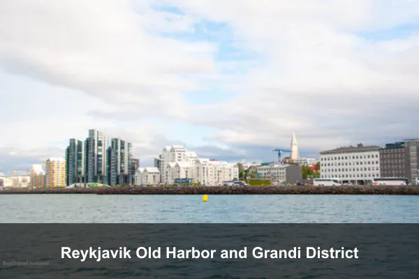
Reykjavik’s Old Harbor and nearby Grandi District in southwest Iceland’s city center make an ideal culture-and-food base between waterfall and glacier days: you can visit design-forward museums, eat some of the capital’s best seafood, then join whale-watching departures right from the harbor. The area works year-round, with June to August offering long daylight for extended harbor walks and November to March bringing a cozy winter atmosphere of lit cafés and sea views. Practicality is easy too, since KEF is about 45 minutes away by airport bus or taxi, so you can settle in quickly after landing. If you plan to combine multiple museums with local bus rides, a Reykjavik City Card often pays for itself fast.
| Best for | Design museums, seafood spots, and whale-watching departures |
|---|---|
| Location | Southwest Iceland, Reykjavik city center |
| Best time | Year-round; June-Aug for long days, Nov-Mar for winter atmosphere |
| Access | About 45 minutes from KEF by airport bus or taxi |
Additional Info: A Reykjavik City Card can pay off quickly if you combine museums with local bus rides.
Thingvellir National Park and Silfra Fissure
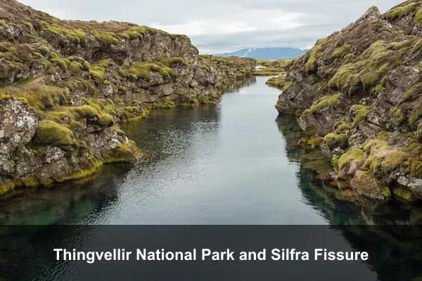
Thingvellir National Park and the nearby Silfra Fissure are where Iceland’s raw geology becomes an adventure: you can walk the dramatic rift valley between the North American and Eurasian plates, then snorkel or dive in Silfra’s crystal-clear glacial water. Located on the Golden Circle about 45 km east of Reykjavik, this stop works well as a self-drive trip via Route 36 or on a classic Golden Circle day tour. Visit from May to September for the best trail conditions, while Silfra tours run most of the year. For the best visibility and cleaner photos, book an early Silfra slot when the water is calmer and crowds are lighter.
| Best for | Rift-valley walks and Silfra snorkeling or diving |
|---|---|
| Location | Golden Circle, roughly 45 km east of Reykjavik |
| Best time | May-Sep for trails; Silfra tours run most of the year |
| Access | Self-drive on Route 36 or join a Golden Circle day tour |
Additional Info: Choose an early Silfra timeslot for calmer water and fewer people in your photos.
Gullfoss Waterfall
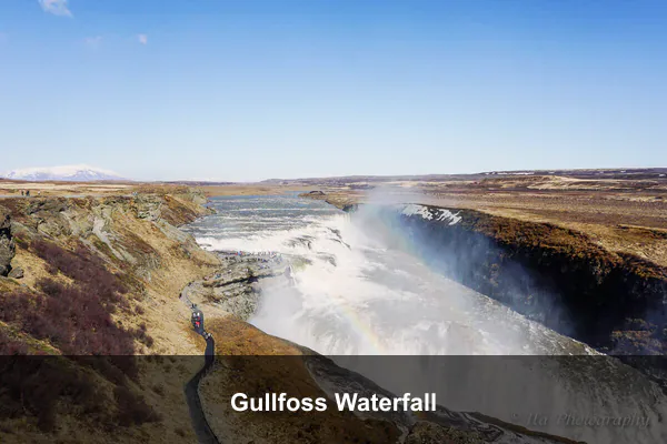
Gullfoss Waterfall is a must-stop on the Golden Circle, where the Hvita River plunges into a dramatic canyon in one of Iceland’s most powerful cascades. It is best for classic waterfall views and short scenic stops, with multiple easy viewpoints connected by paths so you can see both the upper and lower drops without a long hike. Visit from June to September for frequent rainbows in the spray, or from December to February for striking icy canyon scenery. Access is simple via a paved approach road, about 1 hour 45 minutes from Reykjavik, making Gullfoss an easy day-trip highlight. Mist can soak clothing quickly, so keep a waterproof outer layer handy even on sunny days.
| Best for | Classic waterfall views and short scenic stops |
|---|---|
| Location | Hvita River canyon, Golden Circle |
| Best time | Jun-Sep for rainbows; Dec-Feb for icy canyon scenery |
| Access | Paved approach road, about 1 hour 45 minutes from Reykjavik |
Additional Info: Mist can soak clothing fast, so keep a waterproof outer layer handy even on sunny days.
Reynisfjara Black Sand Beach and Dyrholaey
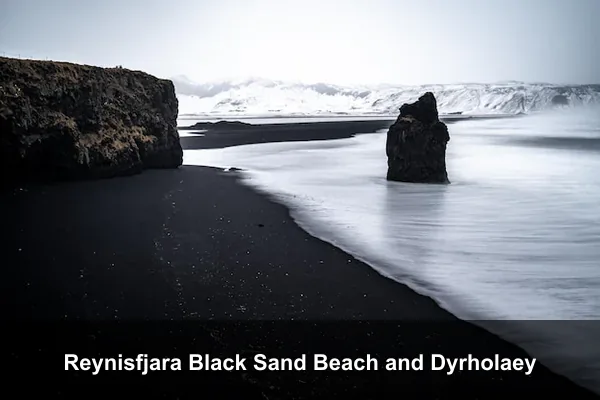
Near Vik in South Iceland, Reynisfjara Black Sand Beach and nearby Dyrholaey deliver one of the country’s most dramatic South Coast scenes: jet-black sand, hexagonal basalt columns, roaring Atlantic surf, Reynisdrangar sea stacks, and high cliff viewpoints. Visit for coastal photography, short cliff walks, and seabird spotting, especially puffins from April to October, while winter brings powerful, cinematic wave conditions. The area works well as a day trip, about 2.5 to 3 hours from Reykjavik via Route 1. Stay strictly within marked safe zones and never turn your back to the ocean, as sneaker waves here are sudden and dangerous.
| Best for | Black-sand coastlines and Atlantic cliff panoramas |
|---|---|
| Location | Near Vik, South Iceland |
| Best time | Apr-Oct for seabirds; winter for dramatic wave conditions |
| Access | About 2.5-3 hours from Reykjavik via Route 1 |
Additional Info: Never turn your back to the ocean here because sneaker waves are sudden and dangerous.
Jokulsarlon Glacier Lagoon and Diamond Beach
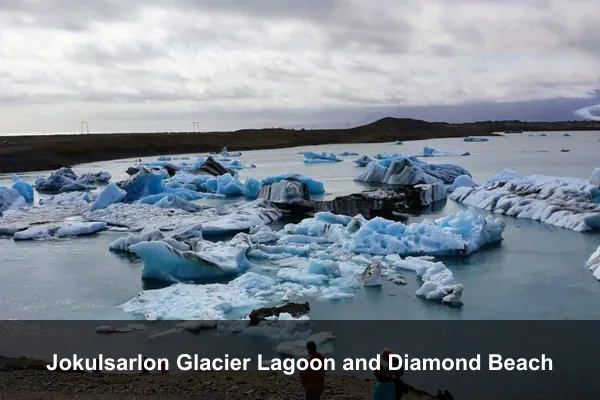
Jokulsarlon Glacier Lagoon and nearby Diamond Beach in southeast Iceland’s Vatnajokull region pack floating icebergs, coastal light, and wildlife into one compact stop. It’s one of Iceland’s best places for iceberg photography, seal spotting, and boat tours: capture sculpted ice drifting through the lagoon, watch seals surface near the shore, then take a zodiac tour for close glacier views (best from May to September). From November to March, blue-toned ice against black sand creates striking winter contrast. Sunrise usually brings softer light and fewer crowds around the main lagoon viewpoints, making it the best time to shoot photos. Plan roughly five hours from Reykjavik via Route 1, or visit as part of a multi-day South Coast itinerary.
| Best for | Iceberg photography, seal spotting, and boat tours |
|---|---|
| Location | Southeast Iceland, Vatnajokull region |
| Best time | May-Sep for zodiac tours; Nov-Mar for blue-toned winter contrast |
| Access | Around 5 hours from Reykjavik on Route 1 or via multi-day tours |
Additional Info: Sunrise usually offers softer light and fewer crowds around the main lagoon viewpoints.
Skaftafell in Vatnajokull National Park
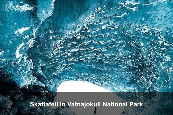
Skaftafell, in Vatnajokull National Park, is one of South Iceland’s best bases for guided glacier hikes, easy day walks, and classic waterfall viewpoints, including the popular Svartifoss trail. Set between Kirkjubaejarklaustur and Hof, it gives quick access to varied routes without long transfers, from short scenic loops to full-day glacier adventures with local guides. Visit from June to September for full trail access, or come in the shoulder seasons for lighter crowds and a quieter atmosphere. Practical tip: start popular hikes early in the morning, before midday coach arrivals can bottleneck narrow path sections. Access is simple via direct parking at the Skaftafell visitor center just off Route 1.
| Best for | Guided glacier hikes and the Svartifoss trail |
|---|---|
| Location | South Iceland between Kirkjubaejarklaustur and Hof |
| Best time | Jun-Sep for full trail access; shoulder seasons for fewer visitors |
| Access | Direct parking at Skaftafell visitor center off Route 1 |
Additional Info: Start popular hikes early morning to avoid midday coach traffic on narrow path sections.
Landmannalaugar Highlands
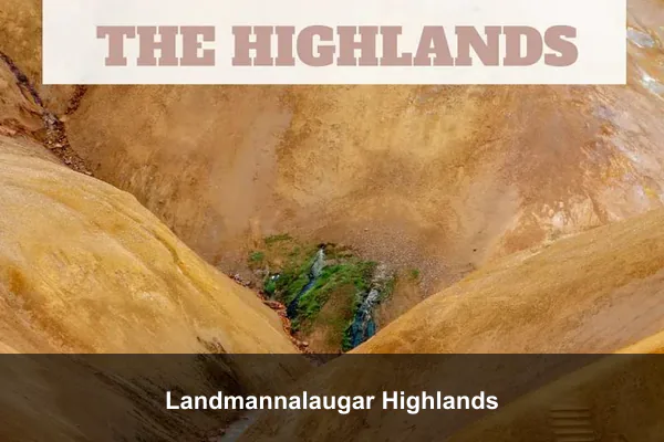
Landmannalaugar in Fjallabak Nature Reserve is Iceland’s most vivid highland escape, where striped rhyolite mountains, lava fields, and steaming vents create unforgettable volcanic panoramas. Come for highland trekking on trails like Laugahraun or short out-and-back walks, then soak in the natural hot spring beside the campsite for a classic geothermal bathing experience. This area is best visited only from late June to early September, when routes are open and conditions are safer. Access is part of the adventure: reach it by 4×4 on F-roads or take a summer highland bus from Reykjavik. If you plan to hike even short sections, pack sturdy sandals for stream crossings.
| Best for | Highland trekking, geothermal bathing, and volcanic panoramas |
|---|---|
| Location | Fjallabak Nature Reserve, central Highlands |
| Best time | Late June to early September only |
| Access | 4×4 via F-roads or summer highland bus from Reykjavik |
Additional Info: Pack sandals for stream crossings if you plan to hike even short sections of nearby trails.
Lake Myvatn Geothermal Area
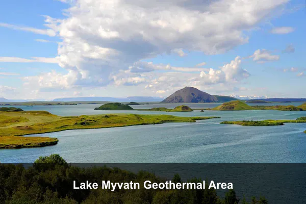
Lake Myvatn Geothermal Area, in North Iceland near Reykjahlid, packs dramatic volcanic scenery into an easy-to-explore zone of pseudo-craters, black lava fields, bubbling mud pots, and steaming vents. It is best for travelers who want geothermal landscapes, crater walks, and a soak in nature baths, with highlights like Hverir and the Myvatn Nature Baths. Visit June to August for the best hiking conditions and longer daylight, or September to March for a chance to catch aurora nights after dark. The area is straightforward to reach, about a one-hour drive from Akureyri, and in summer a lightweight midge net is highly recommended because insects can be intense along the shoreline.
| Best for | Geothermal landscapes, crater walks, and nature baths |
|---|---|
| Location | North Iceland near Reykjahlid |
| Best time | Jun-Aug for hiking; Sep-Mar for possible aurora nights |
| Access | About 1 hour by car from Akureyri |
Additional Info: Bring a lightweight midge net in summer because insects can be intense around the shoreline.
Snaefellsnes Peninsula

Snaefellsnes Peninsula is a compact West Iceland loop around Snaefellsjokull National Park that packs dramatic coastlines, mossy lava fields, and characterful fishing villages into one easy trip. Come for classic Kirkjufell views, then spend the day on sea-cliff walks, black-pebble shores, and quick stops in small towns like Arnarstapi, Hellnar, and Stykkisholmur. It is about 2–3 hours from Reykjavik by car, making it ideal as a long day trip or overnight circuit. May to September offers easier driving and longer daylight, while winter brings moody light, fewer visitors, and a wilder atmosphere. Practical tip: refuel before entering the peninsula core, where gas stations are less frequent than around the capital region.
| Best for | Kirkjufell views, coastal walks, and small-town stops |
|---|---|
| Location | West Iceland around Snaefellsjokull National Park |
| Best time | May-Sep for easier driving; winter for moody light and fewer visitors |
| Access | Roughly 2-3 hours from Reykjavik by car |
Additional Info: Refuel before the peninsula core, since gas stations are less frequent than in the capital region.
Heimaey in the Westman Islands
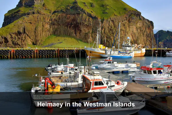
Heimaey, the largest island in the Vestmannaeyjar archipelago off Iceland’s south coast, is a rewarding side trip for travelers who want dramatic lava history, lively harbor-town charm, and some of Iceland’s best coastal wildlife. Walk the Eldheimar museum and eruption sites to understand the 1973 volcano that reshaped the town, then hike volcanic ridges or cliffs where thousands of puffins nest in summer. Visit from May to August for peak puffin viewing, while volcano museums and many hikes are worthwhile year-round. Reach Heimaey by a 35-minute ferry from Landeyjahofn or a short flight from Reykjavik, and keep your return plans flexible since rough seas can delay ferry schedules.
| Best for | Puffin colonies, lava history, and harbor-town atmosphere |
|---|---|
| Location | Vestmannaeyjar archipelago off Iceland’s south coast |
| Best time | May-Aug for puffins; year-round for volcano museums and hikes |
| Access | 35-minute ferry from Landeyjahofn or short flight from Reykjavik |
Additional Info: Keep your return schedule flexible because sea conditions can affect ferry timing.
Tips Before You Go
Book key logistics early, especially if you are traveling June through September: rental cars, countryside hotels, and popular tours can fill up months ahead. If your plan includes Highland routes, confirm that F-roads are open and use a 4×4 rated for those conditions.
Pack for fast weather changes with windproof layers, waterproof shoes, and backup clothing in your day bag. Drive conservatively, check daily weather and road updates before departure, and leave buffer time in your itinerary so storms or strong winds do not force you to skip major stops.